


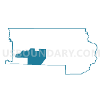
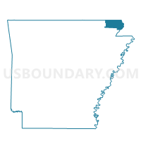
Cache & Wilson Voting District, Clay County, Arkansas
About
Outline

Summary
| Unique Area Identifier | 526130 |
| Name | Cache & Wilson Voting District |
| County | Clay County |
| State | Arkansas |
| Area (square miles) | 62.55 |
| Land Area (square miles) | 62.14 |
| Water Area (square miles) | 0.41 |
| % of Land Area | 99.35 |
| % of Water Area | 0.65 |
| Latitude of the Internal Point | 36.31575910 |
| Longtitude of the Internal Point | -90.57909970 |
Maps

Graphs
Select a template below for downloading or customizing gragh for Cache & Wilson Voting District, Clay County, Arkansas


Neighbors
Neighoring Voting District (by Name) Neighboring Voting District on the Map
- Bennett & Lemmons Voting District, Clay County, AR
- Breckenridge Voting District, Greene County, AR
- Clark Voting District, Clay County, AR
- Crowley Voting District, Greene County, AR
- Gleghorn & South Kilgore Voting District, Clay County, AR
- Johnson Voting District, Clay County, AR
- Knob Voting District, Clay County, AR
- Nelson Voting District, Clay County, AR
Top 10 Neighboring County Subdivision (by Population) Neighboring County Subdivision on the Map
- Gleghorn-South Kilgore township, Clay County, AR (1,754)
- Breckenridge township, Greene County, AR (1,319)
- Bennett-Lemmons township, Clay County, AR (643)
- Cache-Wilson township, Clay County, AR (477)
- Crowley township, Greene County, AR (297)
- Knob township, Clay County, AR (243)
- Johnson township, Clay County, AR (225)
- Nelson township, Clay County, AR (209)
- Clark township, Clay County, AR (193)
Top 10 Neighboring Place (by Population) Neighboring Place on the Map
Top 10 Neighboring Unified School District (by Population) Neighboring Unified School District on the Map
- Greene County Technical School District, AR (18,658)
- Corning Public Schools, AR (7,141)
- Marmaduke School District, AR (3,835)
Top 10 Neighboring State Legislative District Lower Chamber (by Population) Neighboring State Legislative District Lower Chamber on the Map
Top 10 Neighboring State Legislative District Upper Chamber (by Population) Neighboring State Legislative District Upper Chamber on the Map
Top 10 Neighboring 111th Congressional District (by Population) Neighboring 111th Congressional District on the Map
Top 10 Neighboring Census Tract (by Population) Neighboring Census Tract on the Map
- Census Tract 4802, Greene County, AR (4,379)
- Census Tract 9504, Clay County, AR (3,376)
- Census Tract 4803, Greene County, AR (3,208)
- Census Tract 9502, Clay County, AR (2,304)
- Census Tract 9503, Clay County, AR (2,204)
Top 10 Neighboring 5-Digit ZIP Code Tabulation Area (by Population) Neighboring 5-Digit ZIP Code Tabulation Area on the Map
- 72450, AR (36,033)
- 72422, AR (4,979)
- 72436, AR (942)
- 72435, AR (505)
- 72425, AR (446)
- 72453, AR (198)